FROM SALT KARSTS TO LAVA TUBES
– Caves Around the World –| Introduction | Hungary – Cold-water caves |
| Hungary – Hydrothermal caves | Montenegro | Croatia |
| Serbia | Italy-Austria-Germany | Slovenia | Israel |
| Sicily | USA | Yemen | Slovakia | Romania | Turkey |
| Explortion and Scientific Research |
Berentés Ágnes
FROM SALT KARSTS TO LAVA TUBES
– Caves Around the World –
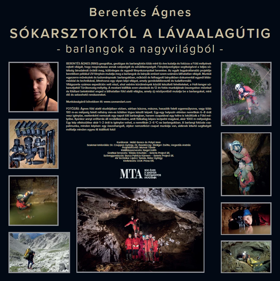
Ágnes Berentés (b. 1990) is a geographer, geologist and cave photographer who has spent more than a decade exploring and photographing the hidden world beneath the Earth’s surface, revealing both its beauty and fragility. With her camera, she captures the realm of complete darkness, creating distinctive and unique lighting conditions.
In one of her most remarkable projects, she uses ultraviolet light to reveal features in caves and mines that are invisible to the human eye. Her work is both artistic and scientific: with a distinctive visual approach and technique, she documents caves as well as active and abandoned mines, creating a visual world that encourages reflection and raises awareness.
She has taken part in numerous expeditions around the world, working under extreme conditions, from the salt karsts of the Dead Sea to the depths of Turkey. This exhibition brings together these journeys and 12 years of photographic work, offering both an artistic and geological insight into the invisible underground world and presenting caves from a new perspective – as living and vulnerable systems.
More about her work: www.caveandart.com
PHOTOGRAPHY
In her underground studio, Ágnes creates her photographs while crawling through water and mud, climbing, balancing above deep fissures, or hanging from a rope only a few millimetres thick above drops of several hundred metres. Reaching a single location often takes 6–8 hours. Sometimes, rather than spending just one day in a cave, she and her team remain deep underground for an entire week. In such situations, the only equipment and supplies available are those she can physically carry with her, sometimes to depths of up to 1,000 metres.
Creating a single photograph can take 1–2 hours, often in caves where temperatures range between 2 and 6 °C. Cave photography is a team effort: behind every image is the coordinated work of a team, sometimes international. Every photograph exhibited here is also a tribute to their dedication and invaluable support.
Curators: Máté Bence and Potyó Imre
Scientific review: Dr. Czuppon György, Dr. Ruszkiczay-Rüdiger Zsófia, Hegedűs András
Project Manager: Morvai Tünde
Exhibition Organisation: Nagel Edith
Graphic Design: Tóbiás Krisztián – Seleris Project Bt.
Text Editing: Burza Patrícia Kármen – Seleris Project Bt.
AV Technology: Lipecz Tamás, Reisz György
Production: OOK Press Kft.
HUNGARY – COLD-WATER CAVES
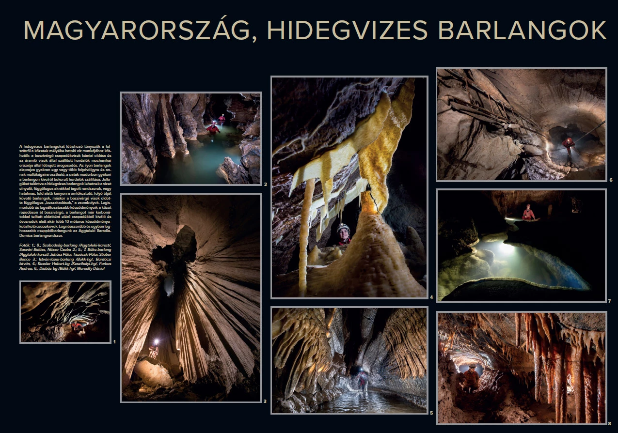
The formation of cold-water caves is linked to the action of water penetrating from the surface into the depths of the rock. Cavities are created through the chemical dissolution caused by infiltrating precipitation and the mechanical erosion produced by sediments transported by flowing water.
The ground plan of these caves often resembles one or more river valleys with their tributaries, while the underground streambeds commonly carry sediments originating from outside the cave. In terms of morphology, cold-water caves may form systems that capture surface water and are intersected by vertical shafts, or vast underground passages resembling canyons and following the course of a river. In other cases, they take the form of vertical shafts, or avens, created by infiltrating water.
Their best-known and most diverse formations are speleothems. These are created from precipitation that seeps through fractures in the rock and reaches the cave as a carbonate-saturated solution. Over thousands of years, this process can produce formations reaching several tens of metres in size.
Hungary’s best-known and longest dripstone cave system is the Baradla–Domica Cave System in the Aggtelek Karst.
Photographs:
1 and 8: Szabadság Cave / Aggtelek Karst / – Sasvári Balázs, Názsa Csaba
2, 5 and 7: Béke Cave / Aggtelek Karst / – Juhász Péter, Tiszóczki Péter, Stieber Bence
3: István-lápai Cave / Bükk Mountains / – Bordáczi István
4: Kessler Hubert Cave / Keszthely Mountains / – Farkas Andrea
6: Diabáz Cave / Bükk Mountains / – Marosffy Dániel
HUNGARY – HYDROTHERMAL CAVES
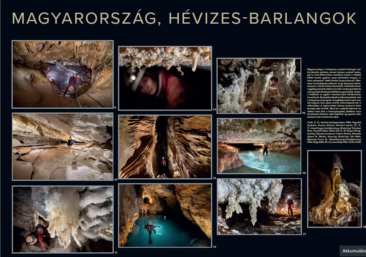
In Hungary, alongside caves formed by cold water, there are also a significant number of caves of hydrothermal origin. These are mainly cave systems dissolved along fractures in the rock by warm or hot waters, often acidic, rising from greater depths.
Their varied morphology is characterised by labyrinth-like passage patterns that follow the fracture systems of the surrounding rock. Their most distinctive solutional features are spherical niches and cupolas decorating the cave walls and ceilings. Calcite plates marking former water levels and distinctive pea-like mineral formations are also common.
Their mineral assemblages are more diverse than those found in cold-water caves. In addition to calcite, the most widespread mineral, aragonite, barite, gypsum, limonite, hydromagnesite and other minerals may also occur.
Hungary’s best-known hydrothermal karst lies beneath the Buda Hills. Because these cave chambers were formed by the dissolving action of water rising from deep underground, they generally have no natural entrances opening onto the surface. As a result, they are often discovered accidentally during construction work.
Photographs:
9 and 13: Ariadne Cave System / Pilis Mountains / – Hegedűs Szabolcs, Kovács Richard, Bordáczi István
10, 11 and 17: József-hegyi Crystal Cave / Buda Hills / – Schubert Nóra, Horváth Gábor, Barko Ali
12 and 16: Berger Károly Cave / Tapolca Basin / – Farkas Andrea, Berentés Ágnes
14: Molnár János Cave / Buda Hills / – Sári Attila, Matuszka Fanni
15: Sátorkőpusztai Crystal Cave / Pilis Mountains / – Nagy Attila
18: Lack Aven / Pilis Mountains / – Zádor Zsófia
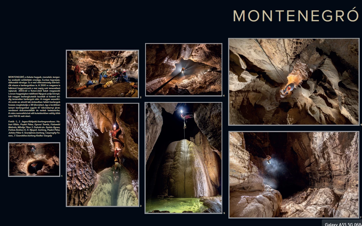
MONTENEGRO
Montenegro, the land of the “Black Mountains” and steep cliffs plunging into the sea, is the wettest region in Europe. This wild diversity of the landscape is also reflected in its caves. Mountain peaks rising to altitudes of up to 2,500 m still conceal many unknowns.
Since 2003, Hungarian speleologists have been exploring the area around Njegoši Polje in the Lovćen Mountains, rising above the Bay of Kotor, in search of previously unknown caves. Over the past two decades, Hungarian expeditions have explored more than 38 km of cave passages. Together with previously known caves, approximately 47 km of underground passages have been documented and catalogued.
The research has since developed into an international project, with more than 700 participants taking part to date.
Photographs 1–2: Jeges-Kétlyukú Cave System – Hubert Kilián, Papkó Péter, Gyovai Tamás, Fialowski Melinda, Mihályi Tibor
Photograph 3: Duboki Do – Spáda Ágnes, Farkas Andrea
Photographs 4 and 6: Njegoš Cave – Papkó Péter, Juhász Péter
Photograph 5: Szentjános Cave – Csepreghy Ferenc
Photograph 7: Szandálos Cave – Kadlec Gergely
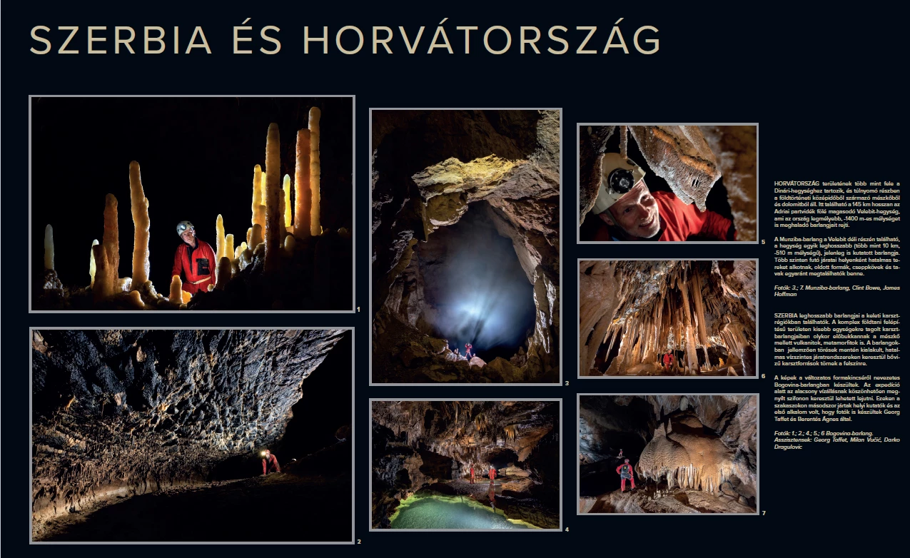
CROATIA
More than half of Croatia lies within the Dinaric Mountains and is composed predominantly of Mesozoic limestone and dolomite. The Velebit Mountains stretch for approximately 145 km along the Adriatic coast and contain the deepest caves in the country, some reaching depths of more than 1,400 m.
Munziba Cave, located in the southern part of the Velebit Mountains, is one of the longest caves in the range, with more than 10 km of passages and a depth of approximately 510 m. Exploration of the cave is still ongoing. Its passages extend across several levels and, in places, open into vast underground spaces. The cave contains a variety of solutional features, speleothems and underground lakes.
Photographs 3 and 7: Munziba Cave – Clint Bowe, James Hoffman.
SERBIA
The longest caves in Serbia are located in the karst regions of the eastern part of the country. The area has a complex geological structure, with the karst divided into smaller units; within the caves, volcanic and metamorphic rocks may occasionally appear alongside limestone.
These caves are typically characterised by extensive horizontal passage systems developed along fractures, through which underground waters emerge at the surface as high-discharge karst springs.
The photographs were taken in Bogovina Cave, known for the diversity of its underground forms. During the expedition, exceptionally low water levels made it possible to pass through a sump and reach these sections of the cave. Local speleologists were entering these passages for only the second time, and this was the first occasion on which they were photographed, by Georg Taffet and Ágnes Berentés.
Photographs 1, 2, 4, 5 and 6: Bogovina Cave
Assistants: Georg Taffet, Milan Vučić, Darko Dragulović.
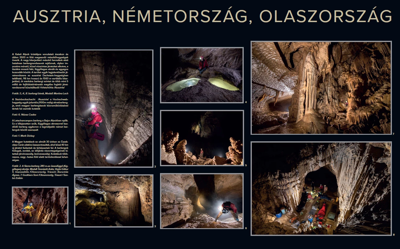
ITALY - AUSTRIA - GERMANY
The crystalline ranges of the Eastern Alps are bordered to the north and south by limestone massifs rising above 2,500 m. Beneath these extensive limestone plateaus lie vast cave systems, sometimes forming impressive, nearly horizontal passages alternating with vertical shafts with water-washed walls and narrow, clay-filled crawlways.
One of the most significant cave systems in the region is Hirlatzhöhle, located in the Dachstein Mountains in Austria. With a length of 116 km and a vertical extent of 1,560 m, the system comprises five distinct cave levels and records more than 5 million years of speleogenetic evolution.
Photographs 3 and 4; Photograph 8: underground bivouac – Martina Lach.
Steinbockschacht, in the Hochschwab Mountains in Austria, is one of the massif’s major vertical caves, reaching a depth of approximately 1,100 m. It was explored by Austrian cavers with the participation of Hungarian speleologists.
Photograph 6: Názsa Csaba.
Latschencanyon Cave, located in the Bavarian Alps, is an exceptionally narrow cave beginning with a series of vertical shafts. It was once ranked among the deepest caves in Germany.
Photograph 1: Mark Dickey.
Over the past 30 years, Hungarian speleological research has focused on the Canin Plateau in northern Italy, where nearly 40 km of new passages have been discovered and mapped. The caves are cold and harsh, and their exploration is exposed to weather-related hazards, including floods and avalanches. Exploring them may require underground stays lasting several days or even weeks.
Photograph 2: the 280 m continuous vertical shaft of Sisma Cave – Szaniszló Anita, Vajda Gábor.
Photograph 5: Impossibile Cave / Italy, Trieste / – Berentés Ágnes.
Photograph 7: Gualtiero Savi Cave / Italy, Trieste / – Szabó Zoltán.
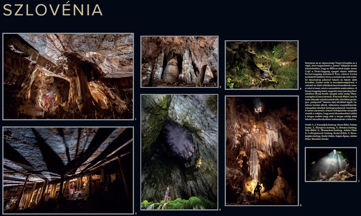
SLOVENIA
Slovenia and the Trieste region of Italy form the landscape of the “Classical Karst”. In the early 1890s, Jovan Cvijić was the first to describe the characteristic surface and underground landforms of the Karst Plateau in the western Dinarides, as well as similar features found in other limestone regions. Since then, these have been referred to as “karst features”, while the dissolution of limestone by water is known as karstification in both Hungarian and international scientific literature.
The larger, eastern part of the Karst Plateau now belongs to Slovenia (Kras), while its smaller western margin lies in Italy (Carso). The plateau is composed mainly of Jurassic and Cretaceous limestones, and its surface is densely dotted with dolines. Beneath it lie extensive cave systems intersected by vertical shafts, opening into vast underground spaces and decorated with a wide variety of speleothems.
Watercourses reaching the margins of the karst are captured by swallow holes and carried underground, only to re-emerge several kilometres away near the sea – or even below sea level – as high-discharge karst springs.
Photographs 1–2: Krempljak Cave – Veres Réka, Fekete Eszter
Photograph 3: Škrinjarco Cave
Photograph 4: Brimšca Cave – Süle Bálint
Photograph 5: Škamprlova Cave – Juhász Péter
Photograph 6: 1 v Kanjaducah Cave – Szabó Zoltán
Photograph 7: Novokrajska Cave – Szabó Zoltán, Gulyás Ágnes, Juhász Péter, Stanislav Danko
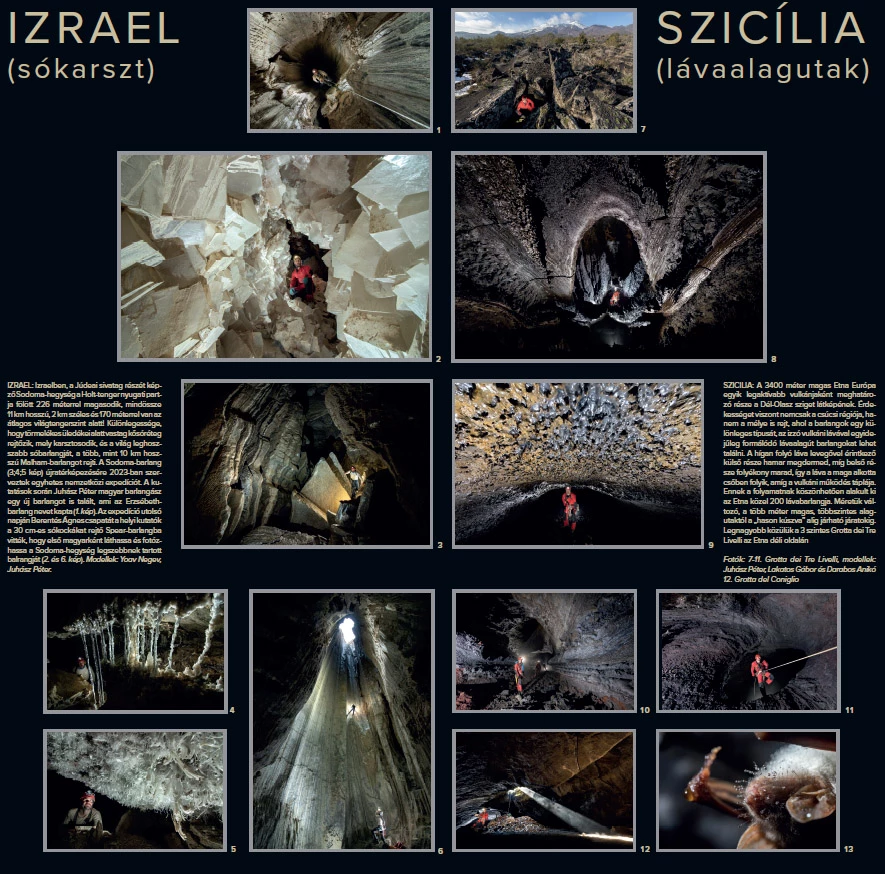
ISRAEL
The Sodom Mountains, part of the Judean Desert, rise 226 m above the western shore of the Dead Sea. The range is only 11 km long and 2 km wide and lies approximately 170 m below mean sea level. Its geological peculiarity is a thick layer of rock salt hidden beneath detrital sediments. This salt undergoes karstification and contains Malham Cave, the world’s longest known salt cave, extending for more than 10 km.
In 2023, a one-week international expedition was organised to re-survey Sodom Cave (photographs 3, 4 and 5). During the exploration, Hungarian speleologist Juhász Péter discovered a new cave, which was named Erzsébet Cave (photograph 1).
On the final day of the expedition, local researchers guided Berentés Ágnes and her team into Spear Cave, known for its approximately 30 cm salt cubes. This gave her the opportunity to become the first Hungarian to see and photograph what is considered the most beautiful cave in the Sodom Mountains (photographs 2 and 6).
Models: Yoav Negev, Juhász Péter.
SICILY (ITALY)
Mount Etna, rising to approximately 3,400 m, is one of Europe’s most active volcanoes and a defining feature of Sicily’s landscape. However, its geological interest is not limited to the summit region: beneath the surface lies a distinctive type of cave, the lava tube, formed simultaneously with flowing molten lava.
As fluid lava comes into contact with the air, its outer surface cools and solidifies rapidly, while the interior remains molten. The lava then continues to flow through the tube it has created for as long as the volcanic activity supplies it.
This process has resulted in the formation of nearly 200 lava caves on Etna. Their dimensions vary greatly, from multi-level tunnels several metres high to passages so narrow that they can only be traversed by crawling.
The largest of these is Grotta dei Tre Livelli, located on the southern flank of Etna and developed on three levels (photographs 7–11).
Models: Juhász Péter, Lakatos Gábor, Darabos Anikó
Photograph 12: Grotta del Coniglio.
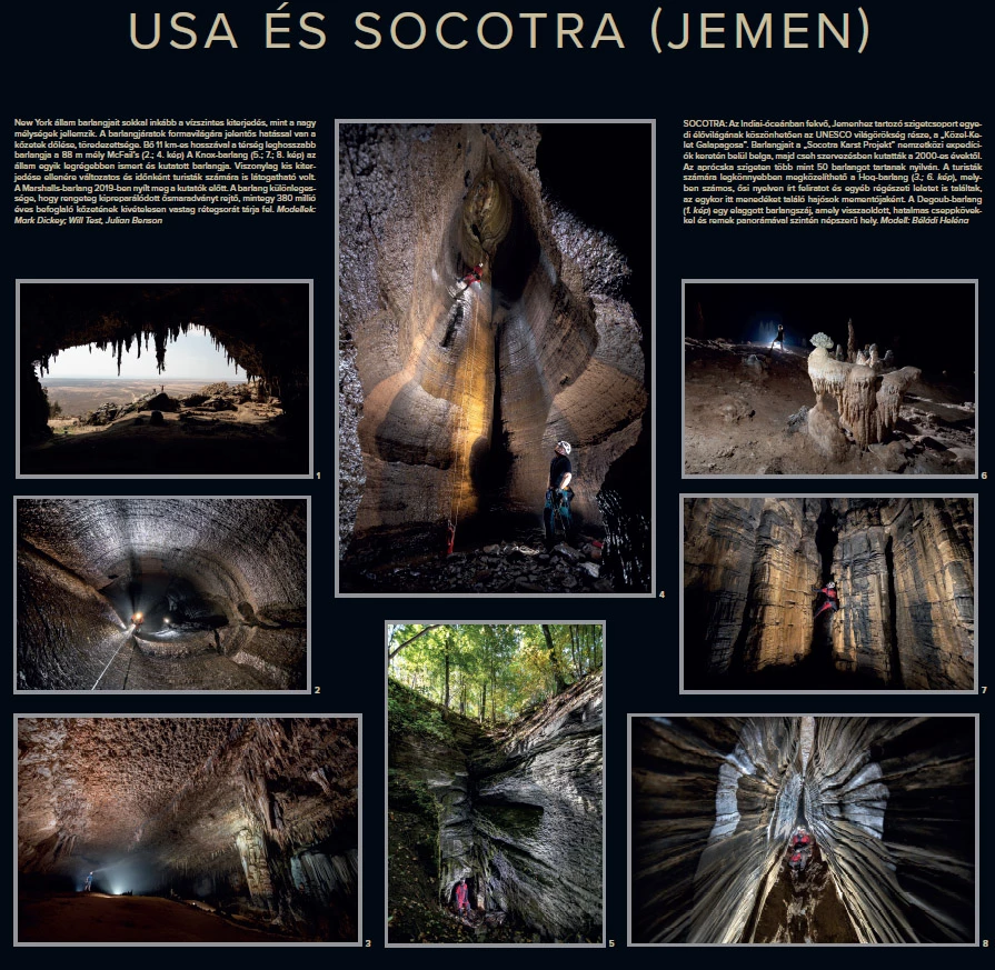
UNITED STATES (New York State)
Caves in New York State are characterised more by their horizontal extent than by great depth. The morphology of the cave passages is strongly influenced by the dip and fracturing of the host rock.
With a length of more than 11 km and a depth of 88 m, McFail’s Cave is the longest cave in the region (photographs 2 and 4). Knox Cave (photographs 5, 7 and 8) is one of the oldest known and most extensively explored caves in New York State. Despite its relatively small size, it is remarkably diverse and was, at times, also open to visitors.
Marshalls Cave became accessible to researchers in 2019. Its distinctive feature is an exceptionally thick sequence of approximately 380-million-year-old host rock containing numerous naturally exposed fossils.
Models: Mark Dickey, Will Test, Julian Benson.
SOCOTRA (YEMEN)
The Socotra Archipelago, located in the Indian Ocean and belonging to Yemen, is a UNESCO World Heritage Site due to its unique biodiversity and is often referred to as the “Galápagos of the Middle East.”
Since the 2000s, its caves have been explored through international expeditions organised within the framework of the “Socotra Karst Project,” initially by Belgian and later by Czech teams. More than 50 caves are known on this relatively small island.
The most easily accessible cave for visitors is Hoq Cave (photographs 3 and 6), where numerous inscriptions in ancient languages and other archaeological finds have been discovered, serving as reminders of the sailors who once found refuge there.
Degoub Cave (photograph 1) is an old cave entrance featuring massive, partly redissolved speleothems and spectacular panoramic views, making it another popular destination.
Model: Béládi Heléna.
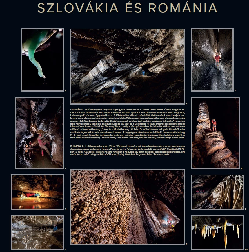
SLOVAKIA
The largest karst region of the Northwestern Carpathians is the Gömör–Torna Karst. Its northern and more extensive part, the Slovak Karst, consists of plateaus lying at elevations of 500–600 m, including the Silica Plateau and Felső-hegy (Upper Mountain) near Torna. Its lower-lying southern continuation forms the Aggtelek Karst. Beneath these plateaus, composed mainly of Triassic limestone, extensive cave systems, vertical shafts and ponors have developed.
Gombasek Cave (photographs 2 and 9), known for its metre-long straw stalactites and open to tourists, also has an active stream passage that is accessible only to cavers. Several large vertical shafts are found on the plateau, including Csengő Shaft (photograph 8) and Barázdálás Shaft (photograph 6), which can only be explored using rope techniques.
In the karst areas bordering the crystalline massif of the Low Tatras to the north and south lie Malužiná Cave (photograph 1) and Modrá Cave (photograph 10). The latter is known for its dolomitic host rock as well as its distinctive blue and green speleothems.
In the northern foothills of the mountain range lies the Demänovská Cave System (photographs 4 and 5), the longest cave system in Slovakia, renowned for its large speleothems and vast underground spaces.
Models: Tardos Dániel, Farkas Andrea, Dave Watts, Ruth King, Mikuláš Repaský, Juhász Péter, Gabriel Jakab.
ROMANIA
In the Apuseni Mountains, in the Padiș and Pădurea Craiului areas, Peștera Ponorăș is one of the most spectacular active stream caves, richly decorated with speleothems. It was explored in 1979 by the Cluj Amateur Speleologists’ Club (CSA-Cluj) (photograph 3).
The Zapodie–Peștera Neagră system is an active stream cave of the massif, intersected by vertical shafts. Its name derives from the dark colour of the host rock in which it developed (photograph 7).
Models: Zsigmond Péter, Szerencsi Judit.
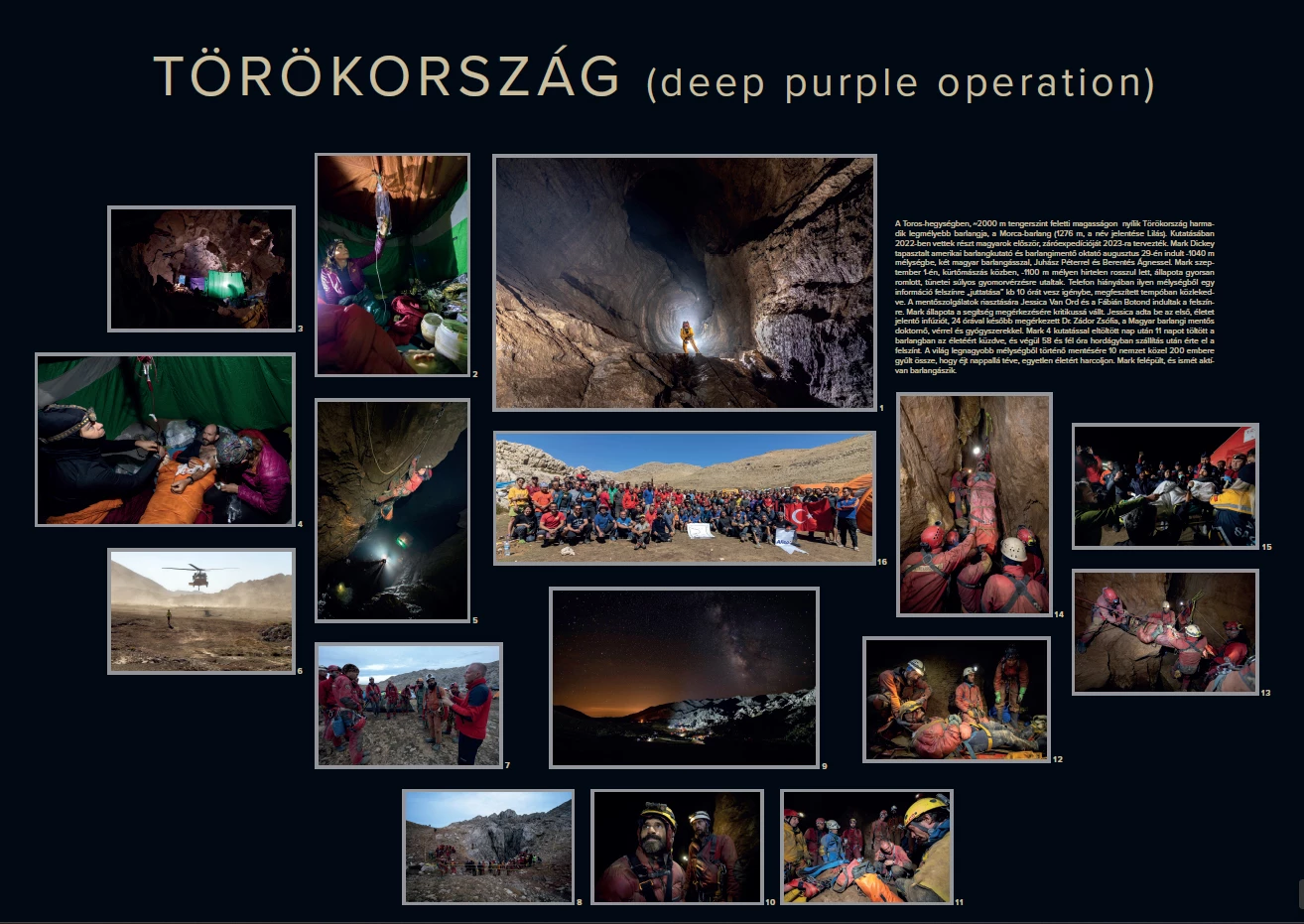
TURKEY
Morca Cave, located in the Taurus Mountains at an altitude of approximately 2,000 m above sea level, is the third-deepest cave in Turkey, reaching a depth of 1,276 m. Its name means “lilac”.
Hungarian cavers first took part in its exploration in 2022, and the final expedition was planned for 2023. On 29 August, experienced American caver and cave-rescue instructor Mark Dickey set off towards a depth of –1,040 m together with two Hungarian cavers, Juhász Péter and Berentés Ágnes.
On 1 September, while climbing a chimney at a depth of approximately –1,100 m, Mark suddenly became ill and his condition deteriorated rapidly. His symptoms indicated severe gastrointestinal bleeding. With no telephone communication available, getting information from such a depth to the surface takes approximately 10 hours, even when travelling at a sustained, rapid pace. Jessica Van Ord and Fábián Botond set off for the surface to alert the rescue services.
By the time help arrived, Mark’s condition had become critical. Jessica Van Ord administered the first life-saving intravenous infusion. Twenty-four hours later, Zádor Zsófia, a physician with the Hungarian Cave Rescue Service, arrived with blood and medication.
After four days spent exploring, Mark remained underground for a further 11 days, fighting for his life. He eventually reached the surface after 58.5 hours of transport on a stretcher.
Nearly 200 people from ten countries came together for the deepest cave rescue operation ever undertaken, working day and night to save a single life. Mark recovered and is once again actively caving.
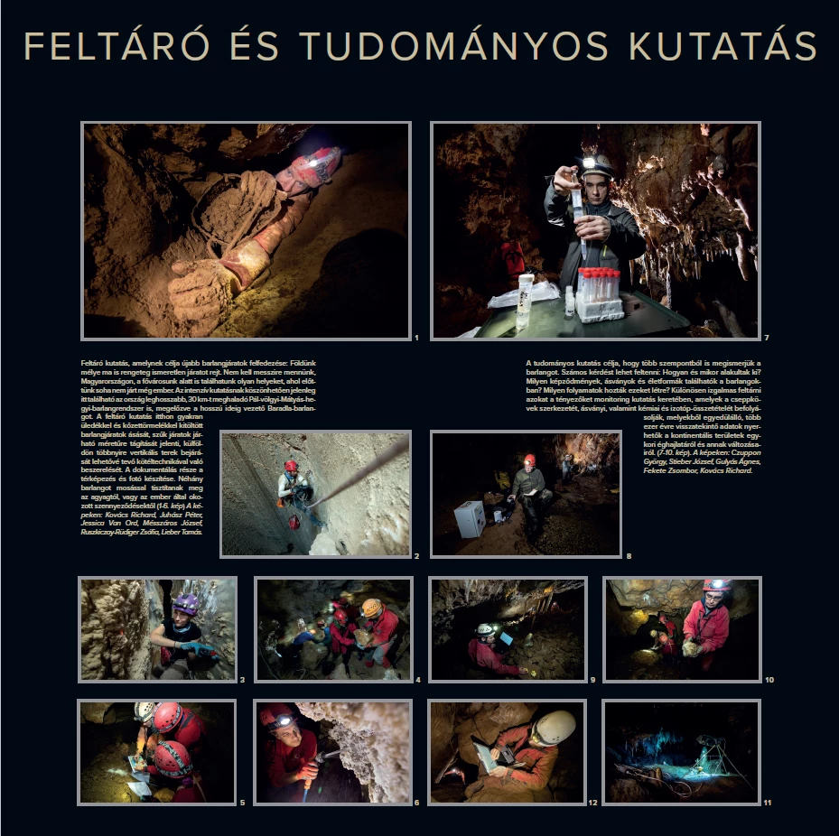
CAVE EXPOLATION AND SCIENTIFIC RESEARCH
Cave exploration aims to discover previously unknown underground passages. The depths of our planet still conceal many unexplored spaces. There is no need to travel far: even in Hungary, beneath the capital, Budapest, new passages are still being discovered where no human had ever set foot before.
As a result of intensive exploration, Hungary’s longest cave system is now located here: the Pál-völgyi–Mátyás-hegyi Cave System, with a length exceeding 30 km, surpassing Baradla Cave, which held the record for many years.
In Hungary, cave exploration often involves excavating passages filled with sediment and rock debris, as well as widening narrow passages until they become traversable. Abroad, it more commonly involves rigging vertical sections with ropes to make exploration possible. Documentation includes cave surveying and photography. In some caves, clay deposits or human-caused contamination are removed by washing (photographs 1–6).
In the photographs: Kovács Richard, Juhász Péter, Jessica Van Ord, Mészáros József, Ruszkiczay-Rüdiger Zsófia, Lieber Tamás.
Scientific research aims to understand caves from multiple perspectives. Many questions can be asked: How and when did they form? What formations, minerals and life forms occur within them? What processes created them?
Of particular interest are monitoring studies that investigate the factors influencing the structure of speleothems, as well as their mineralogical, chemical and isotopic composition. These formations can provide unique records extending back thousands of years, offering valuable information about past climates in continental regions and how they changed over time (photographs 7–10).
In the photographs: Czuppon György, Stieber József, Gulyás Ágnes, Fekete Zsombor.